thales:leila_gilberto_02032012
Essa é uma revisão anterior do documento!
Tabela de conteúdos
Meeting 02/03/2012
Paper about classifying crop lands
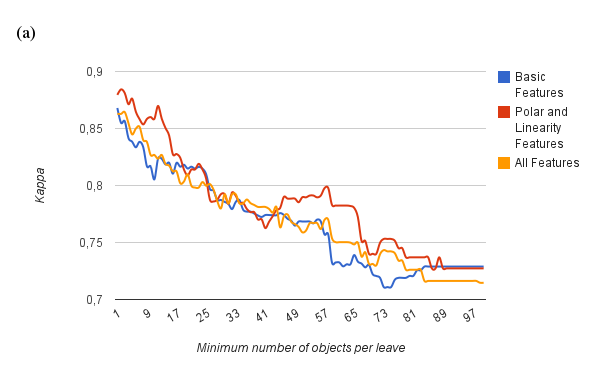
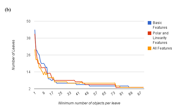
New results, using the seasonal feature of polygon area per quadrant
Results presented in paper
Basic features X Polar Features
First Results, TerraClass (2008) X GeoDMA (growing season 2007-2008)
scene 22469 with 58110 points, and 72% of correct classified points.
scene 22670 with 13629 points, and 85% of correct classified points.
scene 22768 with 83861 points, and 81% of correct classified points.
scene 22969 with 10890 points, and 15% of correct classified points.
scene 22769 with 60286 points, and 77% of correct classified points.
scene 22668 with 65784 points, and 63% of correct classified points.
scene 22770 with 29331 points, and 31% of correct classified points.
scene 22669 with 97752 points, and 77% of correct classified points.
Thesis
First Version
1 Introduction
- 1.1 Scientific Question and Hypothesis
- 1.2 Contributions
- 1.3 Document Organization
2 Review
- 2.1 Landscape Ecology
- 2.2 Object-Based Image Analysis
- 2.3 Data Mining
- 2.4 Multitemporal analysis
3 Method
- 3.1 Defining the input data
- 3.1.1 Segmentation
- 3.1.2 Cycles detection
- 3.2 Feature Extraction
- 3.2.1 Segmentation-based
- 3.2.2 Landscape-based features
- 3.2.3 Multitemporal
- 3.2.3.1 Basic features
- 3.2.3.2 Linearity features
- 3.2.3.3 Features based on polar representation
- 3.3 Data mining to detect land change
- 3.3.1 Building a reference set
- 3.3.2 Classification using decision trees
- 3.4 Output
- 3.4.1 Measuring change
4 Results
- 4.1 Land cover using intra-urban imagery
- 4.3.1 Input dataset
- 4.3.2 Experiment
- 4.2 Detection of patterns of the urban landscape
- 4.3 Classification of agriculture cycles
- 4.4 Evaluating the new multitemporal features
5 Conclusion
Alternative
1 Introduction
2 Paper GeoDMA
3 Paper Polar Features
4 ???
5 Conclusion
thales/leila_gilberto_02032012.1330705446.txt.gz · Última modificação: 2012/03/02 16:24 por tkorting


