Tabela de conteúdos
GeoDMA - Geographic Data Mining Analyst
GeoDMA is a toolbox for integrating remote sensing imagery analysis methods with data mining techniques producing a user-centered, extensible, rich computational environment for information extraction and knowledge discovery over large geographic databases.
Downloads
| Release | TerraView Version | Date | Download link | Release Notes |
|---|---|---|---|---|
| Releases compatible to TerraLib 5 → watch 30sec video (below) to learn how to install GeoDMA 2.0.0 | ||||
| GeoDMA 2.0.5 beta | 5.7.1 | Aug, 30, 2024 | geodma-2.0.5-beta-setup.exe | |
| GeoDMA 2.0.4 beta | 5.6.5 | Aug, 11, 2023 | geodma-2.0.4-beta-setup.exe | |
| GeoDMA 2.0.3 beta | 5.6.1 | Mar, 24, 2021 | geodma-2.0.3-beta-setup.exe | |
| GeoDMA 2.0.1 beta | 5.5.1 | Aug, 4, 2020 | geodma-2.0.1-beta-setup.exe | This is the second beta version, compatible to the original TerraView |
| GeoDMA 2.0.0 beta source-code | 5.4.0 | Nov, 21, 2018 | geodma-develop-2018-11-21-11-03.tar.gz | This file contains ONLY THE SOURCE-CODE for version 2.0.0. To download the latest source-code please check 'Building and Configuring GeoDMA'. |
| GeoDMA 2.0.0 beta | 5.3.3 | Aug, 29, 2018 | geodma-2.0.0-beta-setup.exe | This is the first beta version, compatible to the original TerraView |
| GeoDMA 2.0.0 alpha 3 | 5.3.1 | May, 7, 2018 | geodma-2.0.0-alpha3-setup.exe | This is an alpha version, compatible to the original TerraView |
| GeoDMA 2.0.0 alpha 2 | 5.2.2 | Nov, 6, 2017 | geodma-2.0.0-alpha2-setup.exe | This is an alpha version. It requires a specific version of Terraview 5, downloadable from this link |
| GeoDMA 2.0.0 alpha | 5.2.1 | June, 14, 2017 | geodma2.0.0-alpha_setup.exe | This is an alpha version. It requires a specific version of Terraview 5, downloadable from this link |
| Releases compatible to TerraLib 4 | ||||
| GeoDMA 0.2.2a | 4.2.2 | December, 07, 2015 | install_geodma-0.2.2a.exe | |
| GeoDMA 0.2.2 | 4.2.2 | March, 27, 2014 | install_geodma-0.2.2.exe | This is the first version GeoDMA installer, compatible with TerraView 4.2. |
| GeoDMA 0.2.1 | 4.0.0 | April, 12, 2011 | GeoDMA_021.zip | |
| GeoDMA 0.2.0 | 4.0.0 | March, 17, 2011 | GeoDMA_020.zip | This is the first version compatible with TerraLib 4. |
| Releases compatible to TerraLib 3 | ||||
| GeoDMA 0.1.9 | 3.5.0 | November, 05, 2010 | GeoDMA_019.zip | |
| GeoDMA 0.1.8 | 3.5.0 | October, 21, 2010 | GeoDMA_018.zip | |
| GeoDMA 0.1.7 | 3.5.0 | August, 04, 2010 | GeoDMA_017.zip | |
| GeoDMA 0.1.6 | 3.4.0 | May, 26, 2010 | GeoDMA_016.zip | |
| GeoDMA 0.1.5 | 3.3.1 | May, 11, 2010 | GeoDMA_015.zip | |
| GeoDMA 0.1.4 | 3.3.1 | March, 11, 2010 | GeoDMA_014.zip | |
| GeoDMA 0.1.3 | 3.3.0 | October, 29, 2009 | GeoDMA_013.zip | |
| GeoDMA 0.1.2 | 3.3.0 | September, 16, 2009 | GeoDMA_012.zip | |
| GeoDMA 0.1.1 | 3.3.0 | August, 27, 2009 | GeoDMA_011.zip | |
| GeoDMA 0.1.0 | 3.3.0 | July, 31, 2009 | GeoDMA_010.zip | |
| GeoDMA 0.0.9 | 3.2.0 | May, 12, 2009 | GeoDMA_009.zip | |
| GeoDMA 0.0.8 | 3.2.0 | April, 7, 2009 | GeoDMA_008.zip | |
| GeoDMA 0.0.7 | 3.2.0 | April, 7, 2009 | GeoDMA_007.zip | This is considered the first version published at http://sourceforge.net/ |
How to install GeoDMA in TerraView 5?
It is easy and straightforward. After downloading/installing TerraView 5 in your computer, follow the instructions of this 35 seconds video:
Quick Tutorial - From Raster to Land Cover Map using GeoDMA
Load Raster and Apply Segmentation
The first step is to use TerraView software to load and visualize image (download using this link). We selected the True Color composition for our 4 bands image (Blue, Green, Red, Nir), using bands 2, 1 and 0.
We also applied the 2% image stretching to provide a fast visualization with high contrast. With the image on the screen, we selected the Image Segmentation method to produce regions according. We have selected the minimum number of pixels as 25 to avoid very small regions, and defined a similarity threshold of 0.01, based on the minimum euclidean distance of pixels with 4 bands to be considered homogeneous.
| Loading Raster in TerraView | Apply image segmentation in TerraView |
Extract Features and Select Samples
Based on the regions obtained by the segmentation, we call GeoDMA Feature Extraction tool that produces a table full of features. This process can take several minutes (~15 minutes in this case). We also select samples from the images to train a Decision Tree Algorithm.
| Feature Extraction in GeoDMA | Sample Selection in GeoDMA |
Classify and Visualize Results
The final step is to load the C5.0 classification algorithm, that based on the previously selected samples, produces a Decision Tree and classify all regions. We define a visualization scheme based on the labels included on the table to visualize the final classification.
Description
The toolbox integrates the following techniques:
- image segmentation
- feature extraction and selection
- classification
- landscape-based metrics
- multi-temporal methods for change detection
- spatial data mining with decision-tree based strategies
- simulation methods to accuracy assessment
GeoDMA is developed in C++ under the Free and Open Source Software (FOSS) foundation, and works as a plugin for TerraView GIS.
Applications
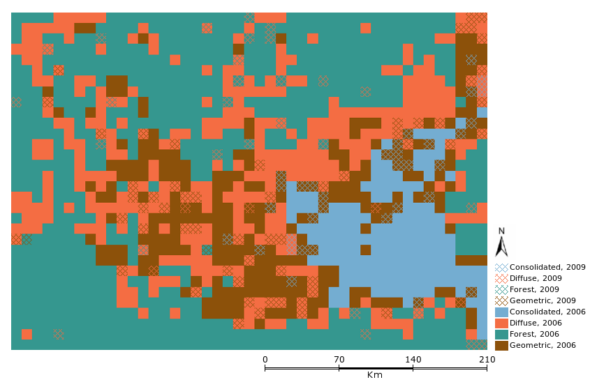
GeoDMA has already been used to classify deforestation dynamics in Brazilian Amazonia.
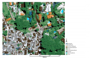
GeoDMA works also with high spatial resolution urban imagery.
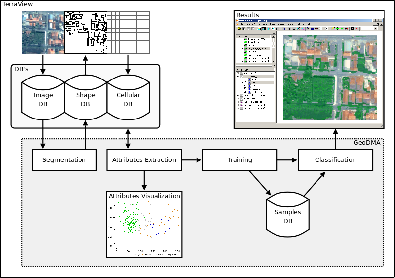
The system's workflow is the following:
People
- Thales Sehn Körting, project manager
- Leila Maria Garcia Fonseca
- Emiliano Ferreira Castejon
Collaborators
- Maria Isabel Sobral Escada
- Antônio Miguel Vieira Monteiro
External Partners
- Marcelino Pereira dos Santos Silva
- Alexandre Noma
Source-code contributions
- Raian Vargas Maretto
- Márcio Azeredo
- Alexandre Copertino Jardim
- Maurício de Paulo
- Ewerton Ribeiro
Documentation
Manuals
Presentations
- GeoDMA: A toolbox integrating data mining with object-based and multi-temporal analysis of satellite remotely sensed imagery. http://bit.ly/slides-thales - PhD thesis in Remote Sensing program (INPE) from Thales Sehn Körting, presented in August, 20th, 2012.
- Classification of remote sensing images with GeoDMA - Geographic Data Mining Analyst (pdf) - Presentation at the “Short Meeting with Prof. Randolph Franklin”.
- Interpreting Images with GeoDMA ppt - Presentation at GEOBIA 2010.
- GeoDMA - discovering patterns from spatio-temporal data (pdf) - Presentation at the “Mini-Colloquium with Dr. Max Egenhofer”.
- Geographical Data Mining - Presentation at the “Joint Research Seminar - GISciente for Dynamic” (ppt)
References
How to reference software GeoDMA in your paper?
GeoDMA <version number>. São José dos Campos, SP: Brazil's National Institute for Space Research (INPE), 2011. Available at <http://www.dpi.inpe.br/geodma>. Accessed in yyyy/mm/dd.
Articles about GeoDMA
- Körting, T.S., Fonseca, L.M.G., Câmara, G. GeoDMA - Geographic Data Mining Analyst. Computers & Geosciences. 2013.
- Körting, T.S., Fonseca, L.M.G., Câmara, G. Interpreting images with GeoDMA. Geographic Object-Based Image Analysis (GEOBIA). Ghent, Belgium. 2010.
- Körting, T.S., Fonseca, L.M.G., Escada, M.I.S., Câmara, G. GeoDMA - Um sistema para mineração de dados de sensoriamento remoto. XIV SBSR. Natal, RN, Brazil. 2009.
- Körting, T.S., Fonseca, L.M.G., Escada, M.I.S., Silva, F.C., Silva, M.P.S. GeoDMA - A novel system for spatial data mining. Data Mining Workshops, 2008. ICDMW '08. IEEE International Conference on. Pisa, Italy. 2008.
Articles using GeoDMA
If you have some paper whose results were produced with GeoDMA, please share with us.
- Silva, N. O., Falcão, E.C. Análise orientada a objetos geográficos, através de árvore de decisão, para classificação da cobertura do solo, no semiárido da Paraíba Anais do XIX SBSR. 2019.
- Gonçalves, V.P., Ribeiro, E.A.W., Imai, N.N. Mapping Areas Invaded by Pinus sp. from Geographic Object-Based Image Analysis (GEOBIA) Applied on RPAS (Drone) Color Images Remote Sensing, v. 14, 2805. 2022.
- Assis, T., Escada, M., Amaral, S. Effects of Deforestation over the Cerrado Landscape: A Study in the Bahia Frontier Land, v. 10, 352. 2021.
- Yanai, A., Paulo, G., Escada, M., Ziccardi, L., Fearnside, P. Deforestation dynamics in Brazil's Amazonian settlements: Effects of land-tenure concentration Journal of Environmental Management, v. 268, 15. 2020.
- Josselin, D., Louvet, R. Impact of the Scale on Several Metrics Used in Geographical Object-Based Image Analysis: Does GEOBIA Mitigate the Modifiable Areal Unit Problem (MAUP)? International Journal of Geo-Information, v. 8, 156. 2019.
- Dutra, A. Shimabukuro, Y. Escada, M.I. Data Mining Using NDVI Time Series Applied to Change Detection, Proceedings, v. 2, 356. 2018.
- Prudente, V.R., Silva, B., Johann, J., Mercante, E., Oldoni, L. Comparative assessment between per-pixel and object-oriented for mapping land cover and use, Journal of the Brazilian Association of Agricultural Engineering, v. 37, 1015-1027. 2017.
- Wallace, L., Saldias, D.S., Reinke, K., Hillman, S., Hallyu, B. Jones, S. Using orthoimages generated from oblique terrestrial photography to estimate and monitor vegetation cover. Ecological Indicators, v. 101, p. 91-101. 2019.
- Maciel, A.M., Silva, M.P.S., Escada, M.I.S., França, F.S. Uma Metodologia para Descoberta de Relacionamentos Frequentes Entre Dados Espaciais de Desmatamento Usando Mineração de Grafos. Simpósio Brasileiro de Bancos de Dados, SBBD. São Paulo, Brazil. 2012.
- Pinho, C.M.D., Fonseca, L.M.G., Körting, T.S., Almeida, C.M., Kux, H.J.H. Land-cover classification of an intra-urban environment using high-resolution images and object-based image analysis. International Journal of Remote Sensing, 2012.
- Meneghetti, G., Rodrigues, C. S. Object-oriented classification in urban areas using GeoDMA plugin. Geographic Object-Based Image Analysis (GEOBIA). Rio de Janeiro, Brazil. 2012.
- Sousa, W., Bandeira, C., Ribeiro, E., Castro, A., Bustos, H., Silva, M.P.S. Monitoring of desertification processes through trend estimates of time series. Geographic Object-Based Image Analysis (GEOBIA). Rio de Janeiro, Brazil. 2012.
- Maciel, A.M., França, F.S., Silva, M.P.S. Discovery of frequent correlations among deforestation objects using graph mining. Geographic Object-Based Image Analysis (GEOBIA). Rio de Janeiro, Brazil. 2012.
- Saito, E.A., Fonseca, L.M.G., Escada, M.I.S., Körting. T.S. Efeitos da mudança de escala em padrões de desmatamento na Amazônia. Revista Brasileira de Cartografia, 63, 401-414. 2011.
- Gavlak, A.A., Escada, M.I.S., Monteiro, A.M.V. Dinâmica de padrões de mudança de uso e cobertura da terra na região do Distrito Florestal Sustentável da BR-163. XV SBSR. Curitiba, Brazil. 2011.
- Saito, E. A., Escada, M.I.S., Fonseca, L. M. G., Körting, T.S. Análise de padrões de desmatamento e trajetória de padrões de ocupação humana na Amazônia usando técnicas de mineração de dados. XV SBSR. Curitiba, Brazil. 2011.
- Sato, L.Y., Martins, F.S.R.V., Cantinho, R.Z., Körting, T.S., Fonseca, L.M.G., Almeida, C., Valeriano, D.M. Classificação de áreas exploradas por sistema de corte seletivo na Amazônia. XV SBSR. Curitiba, Brazil. 2011.
- Saito, E.A., Körting, T.S., Fonseca, L.M.G., Escada, M.I.S. Mineração em Dados Espaciais de Desmatamento do Prodes Utilizando Métricas da Paisagem: Caso de Estudo Município de Novo Progresso - PA. III SIMGEO. Recife, Brazil. 2010.
- Pinho, C.M.D., Silva, F.C., Fonseca, L.M.G., Monteiro, A.M.V. Urban Land Cover Classification from High-Resolution Images Using the C4.5 Algorithm. XXI Congress of the International Society for Photogrammetry and Remote Sensing, Pequim, 2008.
- Silva, M.P.S, Câmara, G. Escada, M.I.S., Souza, R.C.M. Remote Sensing Image Mining: Detecting Agents of Land Use Change in Tropical Forest Areas. International Journal of Remote Sensing, 2007.
For GeoDMA 0.2 and previous versions
Source Code
GeoDMA is free software, developed using TerraLib library. It works as a plugin for TerraView, also free software. If you want to download the source code of GeoDMA, try the following:
- Download TerraLib 4, TerraView and GeoDMA sources using SVN
<https://svn.dpi.inpe.br/terralib/trunk/>
- Use Cmake to create your building files (Windows or Linux)
/path/to/terralib/trunk/build/cmake/
We are currently using Microsoft Visual Studio 2010 with QT 3.2 to compile GeoDMA in Windows, and gcc to compile in Linux. More information about compilation issues, please visit http://www.terralib.org/.


