Essa é uma revisão anterior do documento!
First Paper
An algebraic approach to the composition of sensors
The understanding of complex environmental phenomena, such as deforestation and epidemics, requires observation at multiple scales. This scale dependency is not handled well by today's rather technical sensor definitions. For instance, to understand the impact of deforestation on the local fauna, it is necessary to track the path of individuals as well as the path of populations within a biotope. Movement patterns of individuals reveal information about change in territory and foraging, while the changed behavior of one population impacts the behavior of others. At the scale of the population, a sensor network should produce a single trajectory based on the tracks of the individual animals. Current definitions of sensors, sensor systems, and sensor networks are too technical to capture these abstractions of observations. For example, the definition of geosensor networks as “distributed ad-hoc wireless networks of sensor-enabled miniature computing platforms that monitors phenomena in geographic space” (Nittel et al., 2004) does not admit animals as sensors and cannot relate the phenomena to those observed at other scales. These definitions also exclude human sensors which are the key to volunteered geographic information. We propose definitions of sensors as information sources at multiple scales, relating physical stimuli to symbol systems. An algebraic formalization shows the aggregations, compositions, and generalizations. It also serves as a basis for defining consistent application programming interfaces to sense the environment at multiple scales of observations and with different devices.
Full paper to be submitted March 31 to http://www.comlab.ox.ac.uk/geosensornetworks/
The Context Toolkit A toolkit for context-aware applicationsAnind K. Dey (dey@cs.berkeley.edu) –> http://www.cs.cmu.edu/~anind/context.html
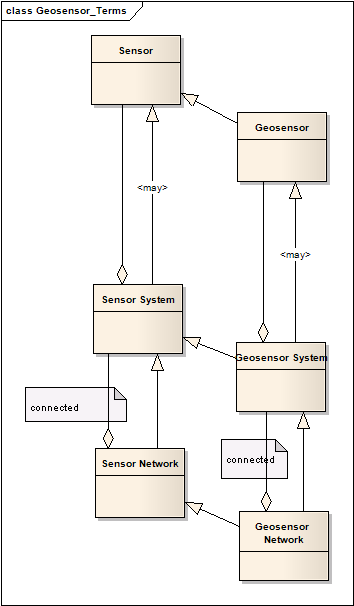
Terms and definitions
Sensor A sensor is an implemented map from physical stimuli into a symbol system.
Example: Step counter for joggers, blood pressure sensor
Geosensor A geosensor is an implemented map from a physical stimulus into a system of georeferenced symbols.
Example: air temperature sensor, acid rain level sensor, human counting aedes ssp. eggs in a egg trap
Sensor System A sensor system is either an aggregation or a composition of sensors, which can behave like a sensor.
Example: system for monitoring blood pressure and heart frequency
Geosensor System A geosensor system is a sensor system containing at least one geosensor. A geosensor system like a single geosensor.
Example: weather station
Sensor Network A sensor network is a spatially distributed and connected network of sensors.
Example: Company wants to know how many of their vehicles are moving at any point in time.
Geosensor Network A geosensor network is a sensor network whose nodes are geosensors.
Example: Wireless Sensor Network for monitoring air pollution at selected locations
Sensor Web “A Sensor Web refers to web accessible sensor networks and archived sensor data that can be discovered and accessed using standard protocols and application program interfaces (APIs).” (Botts et al. 2007)
Example: Weather Forecasting Sensor Web
Observation an act of observing a property or phenomenon, with the goal of producing an estimate of the value of the property. A specialized event whose result is a data value.
Measurement an observation whose result is a measure
Our Proposal:
A framework which allows to pick sensors, tools, statistical methods, standards, and models to support decisions and understanding in geospatial applications at multiple scales. Practical outcome: cookbook.
Ph.D. and master theses proposals:
1. Master
Application of the algebraic view on sensors to the dengue fever (aedes aegypti eggs) use case. This is at the same time our mobility measure: ifgi –> inpe.
2. Master
Development of suitable tools for different sensor abstraction levels. Mobility measure: inpe –> ifgi.
3. Master
At which abstraction level do we need to introduce objects? can we avoid them?
4. Ph.D.
Ontology (SWRL) of processes and data sources for retrieval and composition in the framework (see proposal)
5. Ph.D.
Statistical methods for the conversion between the different abstraction levels of the framework (see proposal).
Second paper
Sensors as Abstract Interfaces Discussion paper for W3C incubator group on geosensors and for OGC
Goal: simplify the sensor web architectures Link to document
Script for presentation
1. Introduction:
-survey of current definitions –> scale dependency is not handled well
2. Definitions:
-basic idea: algebraic specification of sensors
3. Proposal
4. Paper Abstract of first paper
5. Paper title for second paper
6. Thesis proposals and mobility measures

